The Survey
|
|
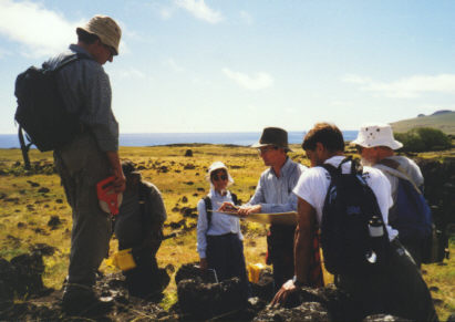
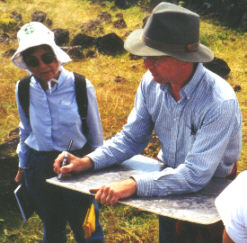
The most important part of the survey process was keeping the aerial photo oriented with the landscape. Chris would stand on a hillside and compare the topography and larger features with details visible in the photo. The photos are a few years old, but the land has not changed much, so even the widely separated groves of trees could be recognized and correlated. Shadows of clouds on the landscape sometimes confused things. Sometimes changing the location and perspective was necessary to to properly orient the team. Barry, Jean, and Carlton wait and Sebastian holds the aerial photo for Chris in the photo at left. |
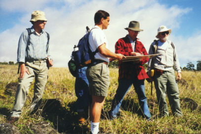
| Having oriented us, Chris
would explain where we were and show us on the map and on the landscape
where we would be be walking. We were broken into a small measuring
team that stayed with him and a larger survey team who would be
field-walking. We rotated tasks each day. At right Chris gives
instructions to Barry, Alex, Jean, Sebastian and Carlton.
Notice the landscape around us in the pictures. It reminded me of the Scottish highlands, especially when the clouds moved in with misty rain. It was early spring and still relatively cool. When the wind rose and the sun disappeared, it felt like Scotland. |
 |
 |
Clemente, in dark blue, a Rapa Nui recently returned from studying archaeology at the University of Chile and now beginning the field work phase of his education, joined us early in the first week. He supervised the field walking, literally loping across rocky terrain the rest of us had some difficulty walking over to place markers to aid our survey. |
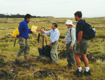
| We were looking for features and groupings of features, or sites, in the survey area. The measuring team, as in the picture below, took the major dimensions of each feature. Chris assigned each site a number, recorded the measurements and a description of each feature at the site, and noted the site number on the aerial photo. Notice the field walkers in the distant background. |
 |
 |
| The survey team also kept an eye out for artifacts, and we found many. A few worked tools are pictured here, but mostly we found chips. A lot of chips indicated a tool shop site. We found a large quarry where basalt was mined and worked. |  |
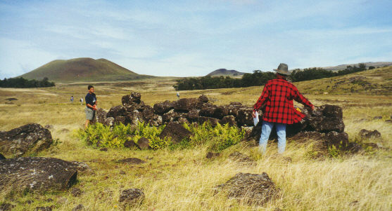
Our exploration was confined
to the survey area, but occasionally we strayed unwittingly. One
somewhat disappointing such misstep occurred on the final survey
morning. After a rather dry period of no features Sebastian and I were
following a string of umu pae, one after another perhaps ten feet
apart. These stopped in jumble of stone. 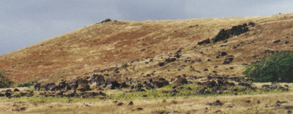 Standing
in the jumble, the color of some of the stones struck me. I suddenly
realized I was looking at a broken moai. Then I spotted another
and another. The jumble was in fact a large ruined ahu,
situated well inland. If your eye is discerning you will see many
toppled moai in the line of stones running across the photo, one
third way up. Standing
in the jumble, the color of some of the stones struck me. I suddenly
realized I was looking at a broken moai. Then I spotted another
and another. The jumble was in fact a large ruined ahu,
situated well inland. If your eye is discerning you will see many
toppled moai in the line of stones running across the photo, one
third way up.
The disappointing part was Chris calling us back and telling us we were outside the project survey area. He did tell me later the discovery was helpful because such a large upland ahu, with its nearby rectangular chief's house, supported his model. |
|
|
|
Although not part of the project, finding myself on this ahu was a high point of the two week experience for me. Another was my afternoon of discovery that followed, described here. |
|
|
|
|
|
This page and its contents © Copyright 1999 Michael & Karen Crisafulli. All rights reserved.